Snow looking more likely in parts of Alabama as winterâs coldest weather arrives
It’s looking more possible that parts of Alabama will get a little snow next week. Although snow in Alabama is never a sure thing.
The National Weather Service was dealing with the possibility of severe weather on Friday but also said winter precipitation could be an issue for parts of north and north-central Alabama from Sunday into Tuesday.
Some of the snow could — could — accumulate in parts of north and north-central Alabama.
However, all of the state will have to deal with what will be the coldest air — by far — of the winter, which will arrive in Alabama starting on Sunday night and last through next week.
Temperatures in the single digits and teens will be possible in north and central Alabama, and even south Alabama could fall into the teens and low 20s before it is over, according to forecasters.
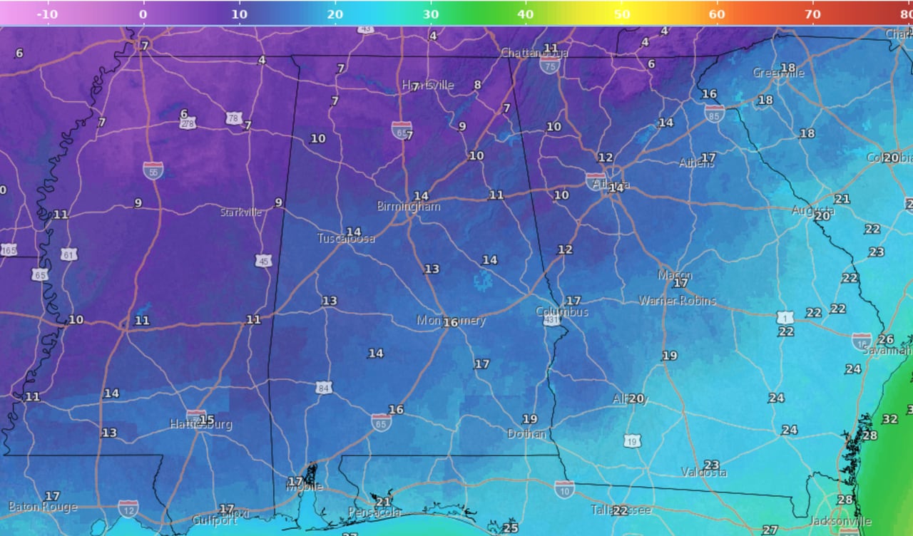
The coldest night is expected to be Tuesday into Wednesday. Here are the forecast low temperatures:
Here are the low temperatures expected from Tuesday night into Wednesday morning.NWS
A strong Arctic cold front is expected to move into Alabama Sunday night into Monday, and it will bring bitterly cold air along with it.
There is the possibility that light snow could start on Sunday night and last through Tuesday morning.
The forecast for cold temperatures has high confidence. The forecast for snow, as always in Alabama, is more tricky. The weather service said there was low confidence when it comes to snow totals for Alabama.
Here’s what forecasters were thinking about snow potential for the different regions of Alabama.
NORTH ALABAMA
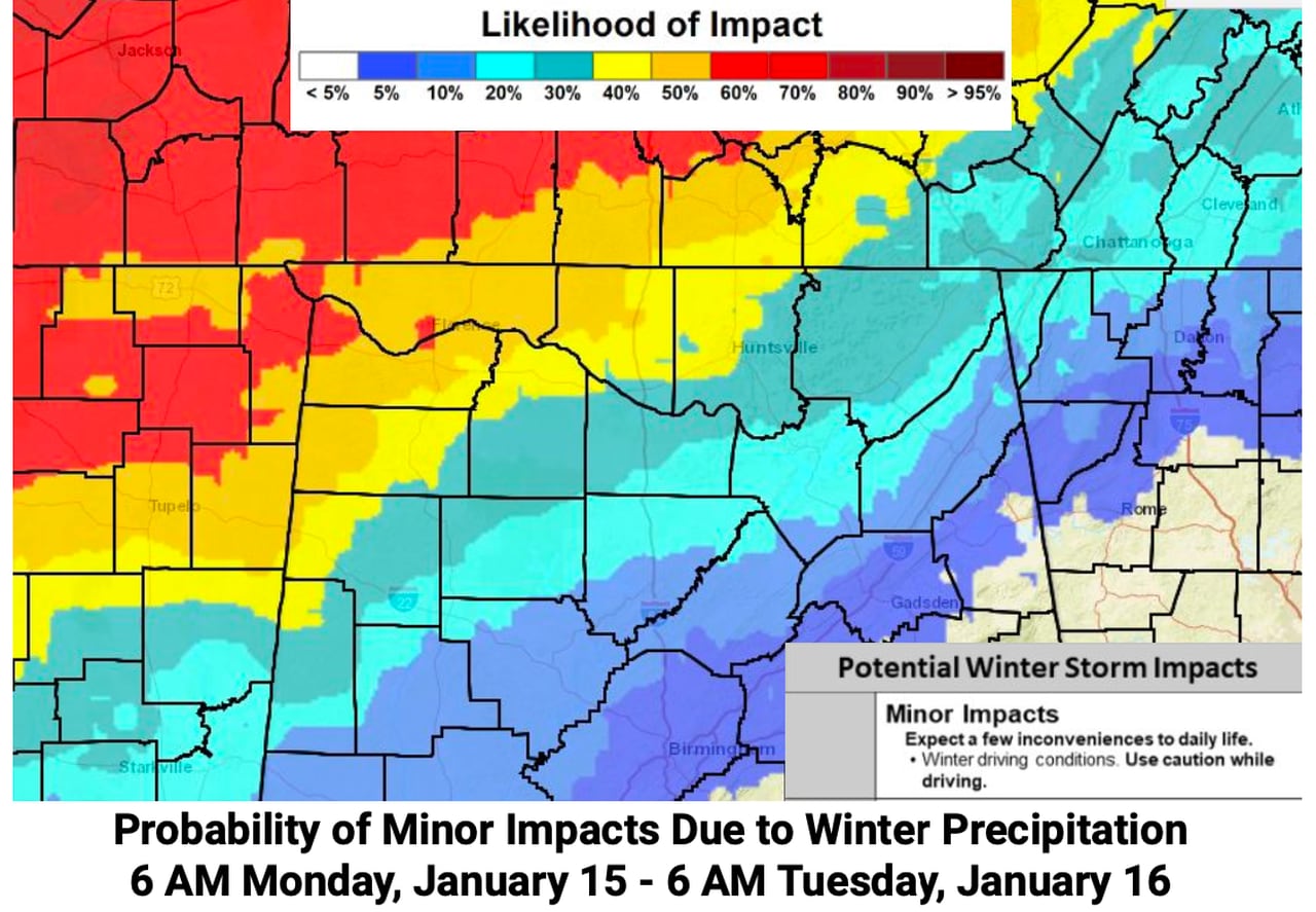
This map shows the probability of winter weather impacts for north Alabama from 6 a.m. Monday into 6 a.m. Tuesday. Note that this is an evolving forecast and could change before next week.NWS
The National Weather Service in Huntsville cautioned that the forecast for winter precipitation for north Alabama was evolving — and changes will be very possible going into next week.
But as of Friday morning forecasters were thinking that there will be low to medium chances for snow Monday and Monday night. Forecasters think the precipitation will arrive in the form of snow.
“While it is still pretty early to get into specifics regarding amounts, models continue to favor at least some snow across the Tennessee Valley Monday into Tuesday,” the weather service said in its Friday morning forecast discussion. “The best timing for snow will come between sunrise Monday morning through the early morning hours on Tuesday.”
Snow totals were expected to remain at less than 2 inches across most of north Alabama.
Northwest Alabama could see the most snow, and more than 2 inches is not out of the question.
CENTRAL ALABAMA
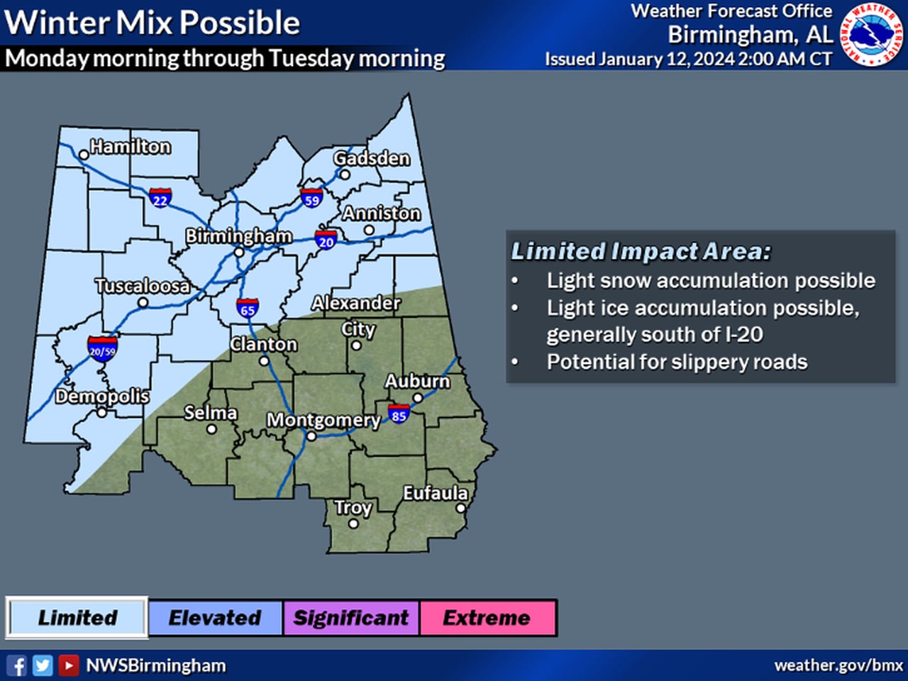
Here’s where winter precipitation is possible in central Alabama Monday and Tuesday.NWS
The National Weather Service in Birmingham said wintry precipitation will be possible for areas north of the Interstate 85 corridor from Sunday night into Tuesday morning.
Forecasters said that areas as far south as I-85 could see a wintry mix potentially changing into snow. However, better chances of anything accumulating will be near and north of Interstate 20.
There will be the potential for slippery roads near and north of I-20.
The weather service said light snow will be possible as early as Sunday night across the northwestern parts of central Alabama, which will transition southeastward Monday and Monday night to along and just south of the Interstate 20 corridor.
Forecasters said “precipitation may be ongoing Monday evening as temperatures fall into the mid-20s across the northwest counties. Any snowfall may quickly accumulate, possibly leading to travel impacts in that part of the area.”
Areas south of I-20 will need to be on guard for possible ice: “There is a non-zero chance of light ice accumulation in areas south of I-20 Monday night into Tuesday morning, where temps will reside around 30 degrees. This, in addition to snow further northwest, will need to be monitored closely for any accumulation with regard to infrastructure and travel impacts,” the weather service said in its Friday morning forecast discussion.
Anything frozen that falls may hang around a while: Some spots in northern central Alabama may not make it above freezing until Wednesday afternoon.
SOUTH ALABAMA
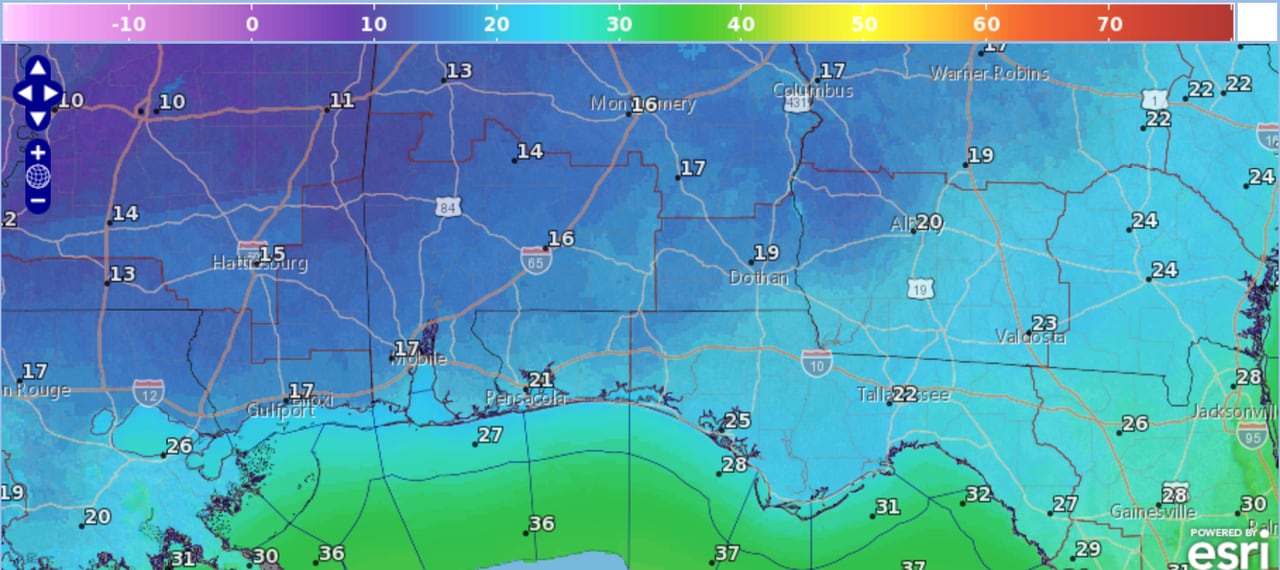
Here are the low temperatures forecast for south Alabama from Tuesday night into Wednesday morning.NWS
The National Weather Service in Mobile said that as of Friday forecasters were leaning toward most of the rain to fall along and ahead of the Arctic front, which means that south Alabama would only be treated to a cold rain.
But, if the front moves faster than expected and precipitation lingers behind it, “then a light wintry mix cannot be ruled out.”
If that were to happen the precipitation type would favor freezing rain, the weather service said, but some sleet could also be possible.
The weather service is forecasting a slight chance for freezing rain inland areas long and west of the Interstate 65 corridor starting on Monday night.